Showing posts with label Hiking. Show all posts

Monday, August 18, 2008

Them Thar Hills!: Along the Tennessee Valley


Last week, I told about my first visit to Mt Tamalpais in over a year and spun a few memories. I didn’t mention that it was quite warm and humid that day, with only a brush of wind on the high grassy slopes overlooking the plate glass, fog-tabled Pacific. From experience, I knew the thick windless forests of Douglas firs up a piece from where I was were humming with hungry bugs, eager to dine on any hapless hiker who dared enter.

And so I drove back down the mountain to another favorite spot.

The Tennessee Valley (named after a steamship that ran aground here in 1853) is a grassland environment. That day, it was combed by gentle sea breezes. The valley, one of Marin County's most popular hiking spots, sits within the National Park Service’s Golden Gate National Recreation Area.

Compared to Mt. Tam, getting there is easy. From Highway 101, take the same Shoreline Highway 1 exit for Stinson Beach; in less than a mile past a slough, there’s a turnoff to the left (be wary and patient; oncoming traffic provides many opportunities for an accident) onto Tennessee Valley for a winding 2-mile drive; the road ends in a large parking lot at the mouth of the valley.

From there, it’s about a 1.7 walk to the beach. The trail splits about a third of the way in; one loop rises to a long mildly muscle-stretching march above the valley; the other, narrower trail, follows the floor through the marsh, leading to the estuary at the end. I like this one, not because I’m lazy, but for its smaller, more surprising wonders.

The frequent fog banks that roll ashore during the summer turn the valley into something like an English moor, redolent of giant spectral dogs and deerstalker-wearing detectives. I first looked down into it from the top of Wolf Ridge, about 800 feet above to the south, during one of my first “epic” walks in the late 1990s; a heart-pumping climb from Rodeo Beach to the ridge, followed by a knee
splitting descent down a twisting ravine into the valley. Then I turned around climbed all the way back up and finished running downhill on the other side to catch the bus back to San Francisco. (My pal Hal, a loyal reader, questioned my sanity with a deep scowl at Frankie’s that evening. “My beer tastes better than yours,” I retorted, with that sneer that only serious hikers can conjure—exhausted body, boosted ego.)


I didn’t really get to see Tennessee Valley until I went with a friend, Alan Brewer, sometime later. As we walked along, I murmured clichéd variations on “Oh wow at the high misty hills. We came to a small beach that was framed by two towering cliffs; the waves thumped through me as they pounded the shore like fists and their foam hissed around our feet; a plump handsome western seagull squawked greedily nearby as we ate trail mix (we were too big for it to bully) We said little, busily
soaking up the spare beauty and menacing power. Even with all the people around, I felt like a survivor pushed to the haunted edge of the world.


Aside from its atmosphere, another thing I like about the Tennessee Valley is that it’s home, like the rest of Marin Headlands to one of my favorite avians, the redwing blackbird. This bird’s crimson patch is a burst of molten fire in black space; I saw none on last week’s trip, though I occasionally heard the electronic wheeze of their call; as I walked along the lower trail, pair of Moms pushing baby carriages approached me and flushed a red-tail hawk from the tall brush. It briefly flew out of the trail and vanished back into the reeds. The valley is one of Marin’s most popular spots for families.

Here, two springtime’s ago, my wife and I witnessed one of nature’s bursts of brutal spectacle. Just as we were approaching the beach, Elizabeth pointed up the brushy slope to our right. There stood a tall, elegant great blue heron, its long head and pointed bill all set toward the ground, as still as a lawn statue. Seconds after I saw it, it attacked the ground with one short stab and came up with a plump, furry, undoubtedly unhappy, vole. The heron took to the air on its broad wings and swooped over to where the estuary had cut a small shallow stream through the
black sand on its journey to the sea. The heron landed in the middle of the stream. A crowd of beachgoers gathered around. The heron doused the vole in the stream again and again, short brutal stabs, like a knife, until its prey was close enough to dead for swallowing. The birds tipped its head back. The vole disappeared down its gullet, making a brief lump in its predator’s throat. We all murmured, amazed, awed, maybe wondering about that day when we would become the vole.

Last week, I saw no bloody spectacle, only the brown pelican you see below, missed by everyone else as it plodded quietly, unobtrusively up the beach into the lagoon (its unusual behavior indicates it may very well have been ill); in summer, the lagoon retreats inland and loses contact with the ocean waters; I walked over to where the pelican disappeared behind the long grass; as I took my photos and some clumsy video, it seemed to have had enough of my attention and slowly, almost resignedly,
disappeared slowly into the reeds.


Sunday, August 10, 2008

Them Thar Hills!: No Other Heaven.


San Francisco from Rock Spring on Mt. Tam

The East Bay Regional Parks are a string of relatively small pleasures. Running north and south, east of San Francisco Bay, many of them consist of golden grasslands, canyons, and mixed forests of oak, madrone, eucalyptus, and some groves of second-growth redwoods. Redwood Regional Park is particularly appealing as are the grassy heights of Briones, (also a working cattle ranch with a Rawhide flavor). Mt. Diablo has a wild majesty when storms blow by or when the springtime flowers bloom. Yet, wherever I go, I sense the grim hum of urban sprawl, like a snoring odorous bear.

In summer, temperatures rise into the 90s by late morning: this area becomes dangerously uncomfortable. That’s when I turn my bootheels west, toward the coast, mostly to my favorite wonderland of all: Marin County’s Mount Tamalpais.


Though not as high as Mt. Diablo, you can see Mt. Tam from almost anywhere in the Bay Area. The 2,571 peak dominates the titular 6,300-acre-state park. It’s a short drive up Highway 101 from San Francisco, across the Golden Gate Bridge, a few miles past the Golden Gate Headlands. From 101, you take the Highway 1 exit to Stinson Beach for a long snaky drive until the road splits in two; you take the right up onto the Panoramic Highway for a snaky ten miles across the mountain’s south slope. Mt. Tam will loom at you on the first rise like a green tidal wave. Most California coastal mountains run north to south, following the coast and the major fault lines. But Mt. Tam is an exception: it runs west to east.

I briefly sampled Mt. Tam in the mid-1980s. In the late 1990s, as I spread into middle-age and my skepticism toward city life deepened, I seized on hiking as the best way to cope with physical change and spiritual entropy. My first hike was to Angel Island in San Francisco Bay; the following weekend, I hopped the Golden Gate Transit bus right by my apartment on Post Street for the 45-minute ride (one transfer) to Mt. Tam’s steep piney slopes.

For over two years I hiked, clambered, climbed, and crawled the 50-miles of trails that braid the landscape, through its delightfully wide variety of ecosystems. Many trails are steep, often rocky, so I started out on short hikes then became more adventurous. The first time I hiked the nearly 3 miles from Stinson Beach up Tolkien-esque Steep Ravine to Pantoll, I raised my fists in triumph but I was really more like a toddler who'd just learned to climb onto daddy's chair.


Radically more daunting was the trudge up steep Willow Camp Fire Road (over 1,500 feet in 3 miles) to the Coast Trail, then over to McKennan Gulch Trail for a 2-mile trip back down, then a long loop back to Stinson where I found the path blocked by a gi-normous eucalyptus that had toppled across the fire road. I bushwhacked up a steep bank on my hands and knees to get around it. I was grateful to learn that I’m not especially sensitive to poison oak.

One Saturday, I started out from Pantoll (park headquarters and the start of most of the main trailheads) and hiked all the way around Mt. Tam’s north side: 8 miles in around 5 or 6 hours. Near the end, I stopped at the top of Wheeler Trail on the northeast slope and checked the map: it seemed to promise a quick trot down to the Hoo-Koo-E-Koo Trail. “Easy,” I sneered and damn near broke my ankles on what turned out to be a rock-jumbled stream bed that would have made a snake weep. At the bottom, I collapsed and was mistaken for dead by several passing hikers. Another memory from that day: the taste of cold beer and watching the afternoon fog pour up over the ridge and down into Muir Canyon. (If you’re up for a truly Gothic experience, nothing beats hiking Mt. Tam in the summertime coastal fog.)

I took risks, but I took them prepared: map, first-aid kit, some food, compass, Swiss Army knife and always always more water than I needed. In those two years I spent most weekends on Mt. Tam, but I only got lost once. It happened like this.

I was single then and joining a hiking group seemed to be a good way to meet chicks. The Mt. Tamalpais Interpretive Association sponsors two kinds of hiking groups: nature lovers and power hikers. I tried the nature lovers’ Saturday hike first but it felt a little slow to me. The following Sunday, I joined the power hikers. And that was how I got lost.

Ten minutes into the hike, I knew I’d never want to go power hiking again. I may walk faster than the Saturday crowd, but I’m still a dawdler, a “oh-gee-what’s that-flower” kind of guy; sometimes I’ll lie down for a nap.

It was when we were stumbling along the foot of the very steep north side of the mountain, that our power hike leader stopped and turned: “Hey! I think we’re lost!” Not long after, as we fought our way back up through thick brush in the heat, she took a look at my beety face and asked, “Say, do you have high blood pressure?”

. . . which of course, did nothing for my blood pressure . . .

I left the
group at that point and was led out on a shorter, alternate route by a forgiving veteran who eased my embarrassment with tales of his own stumbles into danger: “It happens to us all, even old-timers.”


The view from O'Rourke's Bench

For a year, I worked for the association as their volunteer publicist. Not long after, I met Elizabeth (I wanted to stage our wedding here, but it was unworkable). Now that we live in Emeryville, Mt. Tam is a circuitous hour-long drive away. A week ago Friday was the last time I’d visited in over a year. I drove to my favorite area, the west end around Rock Spring. A half mile southwest, overlooking the Pacific you’ll find the bench pictured below. Dad O’Rourke’s words are more eloquent than mine.

(All photos by author)

Sunday, May 4, 2008

Them Thar Hills! Thoughts of Trails, Trails of Thoughts

More pictures than words this week.

Elizabeth and I have made an arrangement: Because she has sculpture class on Saturday in Walnut Creek, on Friday I get the car and some badly needed exercise and fresh air. A few weeks ago, I commenced exploring the north-south string of parks that make up the East Bay Municipal Park District. Covering 91,000 acres, the district runs through the hills above East Bay cities from Richmond and unincorporated El Sobrante (“the leftovers”), through Oakland, to Hayward, Fremont, and San Jose.

We’d already explored much of the area north above the Caldicott tunnel through which Highway 24 runs into Contra Costa County. I decided to wander south. Last summer I explored around Sibley Volcanic Preserve a couple of times, but this year, I decided to start out with the Huckleberry Botanic Regional Preserve, located about two miles south of the intersection with Grizzly Peak Boulevard and Claremont Avenue. (From the west, this is best reached by taking Highway 24 through the Caldicott Tunnel than fanning immediately right up Fish Ranch Road. At the top you make a left onto Grizzly Peak Boulevard. There’s also an exit onto Fish Ranch Road from Highway 24 west.)

The Huckleberry Preserve is smaller than the other parks in the system and is all oak woodland. It was rather a dull hazy day as you can tell from the photo below, taken on March 7.


The trail was pleasant—what trail isn’t?—and only hikers are permitted. But I craved a wider range of environments and greater vistas. The next week, I drove a few more miles south, hooked up with Skyline Boulevard and found greater satisfaction.


Unfortunately, this was the day your correspondent forgot to recharge the batteries on the Canon, so I turned the hike into a workout that turned into an exercise in getting lost—not Dead-Man-Crawling-Lost, but lost as in making a wrong turn and walking all the way to the south end of the park before awaking to my mistake. (Sometimes I’m hiking through the woods; often, like many artist-types, I’m hiking through my thoughts. This was one of those days.) I totaled up six miles and wasn’t that sorry about any of it, especially after that first beer. No sore muscles the next day, either.

The next week, I returned, fully cameraed.

Redwood Regional Park is a 400-foot-or-so-deep canyon—thought no one calls it that--whose ridges are circled by two main trails. The environment is a mix of mostly oak and chaparral at higher elevations, with hushed groves of second growth coast redwoods towering from below. A century ago, this was a major logging site whose wood was major source of building materials. The Bay Area Ridge Trail, whose construction is still in progress, runs through here.

The second Friday, I took the east ridge trail, facing toward Contra Costa County. It was a long, mostly easy, walk, pleasantly uneventful. As you can see, spring was coiled and ready to . . . .


Possibly monkeyflower, though I'm not sure


Baby Blue Eyes? I doubt it . . . .

One remarkable feature is the park’s comparative sense of remoteness. At certain angles, you can fool yourself into thinking you’re seeing things as they were hundreds of years ago, when only the Ohlone people lived in these hills with their low-tech way of life.


The Big City's Not That Far Away

Unfortunately, the hum of the city and the roar of jets overhead from Oakland International Airport are there to remind you otherwise. As are a few signs of civilization like these:

Proof that Little People Exist


The cross, I’m guessing, makes humble reference to Iraq war casualties. Stonehenge . . . ? Yes, little people do live in parks! Why . . . ?

Two weeks later, I took the south ridge. By this time, spring was in full bloom.

Blue-eyed grass; not a grass, but a member of the iris family

Beautiful . . . and unknown
I enjoy taking photos of flowers. It’s more challenging than you think. Digital cameras become unstable when taking close-ups. You’re only seeing the good ones and there aren’t many.

So far, I’ve made my way south of the Chabot Space and Science Center to Roberts Recreation Area.

Chabot Space Center

Roberts Recreation Area is actually a separate park. The second growth redwoods that grow here are descendants of the ones used as reference points by early sailing ships to safely navigate their way into San Francisco Bay.

In Roberts Recreation Area

There’s much ground left to cover. In the meantime, my weight’s down to 175 lbs and my psoriasis has eased somewhat. I'd post pictures, but somehow, sadly, the camera batteries died . . . .

[Reedited 5/5/08; 5/8/08]

Tuesday, November 27, 2007

Them Thar Hills! #2: Time Under Your Feet

“One more picture of the Cat,” Elizabeth warned me the other day, “and that camera goes back to Best Buy for a coffee grinder!”

With those words, off we drove on a cool, cloudless Friday morning after Thanksgiving, up into the Berkeley Hills via broad, snake-winding Claremont
Avenue. At the top of Claremont, at the intersection called “Four Corners,” we turned left onto Grizzly Peak Boulevard and stopped .08 miles further on at the trailhead for Side Hill Trail on the dizzying steep western slope.

About forty people beat us there. Most of them, I suspect, were rockhounds
—amateur geologists—but we were no doubt all of one mind on one issue: Better to expend precious time out in the endless open in relatively cleaner air than to spend Black Friday jostling with the great bargain-desperate mass, unwashed and not, at the mall in search of trinkets whose sparkle would fade the day after the Christmas. Time will always be a greater commodity than money.

This outing was a geology walk hosted by the Claremont Canyon Conservancy down into the same-named canyon. We were tipped off to this event via San Francisco environmental activist Jake Sigg
’s newsletter (jakesigg@earthlink.net). Our articulate guide for the two-hour and about-one-mile stroll through the Claremont Canyon was Doris Sloan, a retired UC Berkeley professor of Geology and author of Geology of the San Francisco Bay Region.

Doris had clearly once been a teacher: She was articulate, bursting with knowledge and passion and even demanding in her crusty way: She fired off occasional pop quizzes as our large group struggled to both keep up and not get too far ahead throughout the walk. I shrank with a subtle embarrassed guilt at how little I knew. Should I raise my hand to ask permission to step into the bushes?

There’s more to the Berkeley Hills than you’d think at first glance, especially if you’re seeing them from the Emeryville
flats. They are a complex, folded and often rugged terrain of canyons and ravines, lumbering north-to-south, a few miles east of San Francisco Bay; hills hiding hills, canyons concealing ravines, many trails weaving about through surprising nooks and crannies. Dozens of varieties of trees grow here, many more than the native oaks and nonnative eucalyptus that are easily identified. Golden meadows sprawl throughout.

Some of the trails aren
’t much wider than a two-by-four. These are my favorites, these are the ones that suddenly sweep a walker out around the ribs of the hills into dizzying panoramas of the East Bay cities below and, the world beyond: San Francisco, the Coast Range rolling south down the San Mateo Peninsula and the Golden Gate. The air was bright and clear enough to see the now oil-stained Farallon Islands, forty miles out in the blue Pacific, clearly visible beyond the Golden Gate Bridge, looking like a sailing ship pushing peacefully south through a calm autumn sea.


My respect for science is vast, though my grasp of it is often shaky, but I can say that there’s tens of millions of years of hidden history in these pretty hills. Only a sliver of of it involves us humans. All of it keeps moving. Once in a great while it moves violently. To geologists worldwide, the Berkeley Hills are a favorite trove of evidence and insight into the ancient, and still profoundly active, forces that have been shaping this little blue home of ours even before
homo sapiens sapiens was a twinkle in the God's Big Eye.

For instance, that bay you see in the photo above: Nine to ten million years ago, it was a mountain range that has long since been shifted by volcanic activity far north to the wine country, over fifty miles away. This movement took place at about the average speed that a fingernail grows, with occasional bursts of several feet caused by the infamous Hayward or San Andreas faults. Several feet doesn
’t sound like much, until you factor in the shift of all that mass and the release of all that power. And the fact that you might be standing on it.

Around that time, the Golden Gate wasn
’t even a gate and it was a long walk to the ocean. The third-highest point in these hills, Round Top, located in the Sibley Volcanic Preserve a few miles south of our location, is an extinct volcano that last saw action millions of years ago and many miles south of its current location. To make it even awesomely stranger, these same tectonic forces have tilted, twisted, folded and finally tipped the now-dormant feature onto its side.

That’s a lot of change for our minds to absorb. And a lot of time. After all, when you look at all that hard, dense rock, it doesn
’t seem to be moving a bit, does it?

But it has. And is.

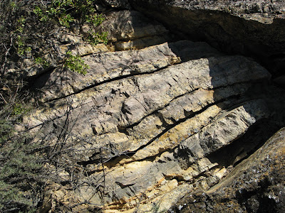
Our walk started at the top, through a field of basalt, a type of shale produced by those volcanic forces mentioned above. Doris Sloan stopped along the way to point out the many features of this material, including dabs of white-streaked red rock that turn out to be the remains of gas bubbles. We stopped at the breaking point between the basalt and an area called the Orinda Formation, where we see several types of rock, indicated by the presences of thousands of stream pebbles. After that, we wound our way to the oldest, most unique ground of all: the Claremont Shale.


Very cool, that Claremont Shale. Bands of white rock, dusted with red, parallel to the ground like layer cake. This shale is not inanimate rock, but something fabulous: a mass of once-living things, known by the delightful word "chert." This formation is made of silica, which are the compressed skeletal remains of sea creatures, millions and million of years old. A couple of hundred feet above the Oakland flats and several miles inland, we were standing on and looking at an old sea bed that continues to rise higher. For this we must thank a process called subduction, which loosely resembles what happens when you try to shove your ultra-thick shag rug under your thin handmade Persian rug.


On the way back up to the top of these hills (which, BTW, are comparatively young), I took a couple of photos (above) of some chevron folds, an especially resistant part of the volcanic layer. Elizabeth remarked on how this brief present-day journey through time past had given her perspective on our place in Life and on Nature’s basic toughness in the face of everything, even our current depredations. Nature always either bounces back or finds her way around. If we fail to take care of what takes care of us, we’re the ones who will be gone. “Nature,” Elizabeth said, “will take care of itself.”

Sunday, August 12, 2007

Them Thar Hills! #1: The Perfect Swimming Hole


Most of what occurred during our vacation in Lake Tahoe was chortle-provoking somehow or other: On the first night, for example, I sliced my fingers open on my razor and staggered about our super-luxurious lodgings, bleeding like Saw X before finding first-aid. For the rest of the night, I stared at the ceiling and wondered if would ever see Emeryville again.

The following incident is perhaps best illustrative of both the adventure I sought and the lesson that brought home that Boy Scout motto: “Be prepared.”

On Wednesday afternoon, my brother-in-law Charles and I took a noonday hike from a trailhead south of Emerald Bay into the Desolation Wilderness. Our destination was Granite Lake, but cartographic confusion took us instead over rocky Cascade Falls Trail to its eponymous destination: a huge fall of granite that rises up from Cascade Lake, before sinking back down into a bowl of high mountains. Numerous streams carved narrow paths through this field, with little hint of the power they carry during spring runoff, but that was OK: We were after bigger game. We were determined to find the perfect swimming hole, even if it killed us. Which it almost did. Me, that is.

Not far from the end of the trail, up the gray slope, Charles heard the sweetest song in nature: the echo of fast running water plunging into a deep pool. The sound led us down into a ravine that was choked with hundreds of fallen conifers, white as bleached bone: It had seen neither fire nor axe in at least a generation. It was so choked with riparian vegetation we could barely find ground to stand on: It was like walking through a game of pick-up sticks played by titans. Charles, the taller of us, bushwhacked on ahead of me, high-stepping like Paul Bunyan through the trackless forest, while I cautiously waded behind like Woody Allen.

My caution failed me, anyway. Despite my careful steps, some support I expected to greet my foot turned out to be illusory. My left hand shot out to stop my fall. Sharp dry wood gouged into my flesh at the base of my thumb and the tip of my first finger. I saw that blood, first. Then I turned my hand over: Saw XI.

“Charles . . . .”

Musn’t panic. Musn’t seem unmanly. My tiny voice bravely squeaked above the woodland hush and the first chatter of birds waking from their afternoon siesta. Crawling one-handed over high horizontal trees, I cautiously followed the sound of falling water, grateful I hadn’t sprained an ankle, or worse.

“Charles.”

I imagined how Charles would react when he saw my blood-spattered form, gaunt and hideous in the green-shadowed woods. (“Oh my God! Tom! Quick! Lie down! No! Don’t move! Here’s all my water! I’ll get the Medivac and fly it in myself!”)

“Charles!”

Finally, the last of my blood gushing from my body, I crawled over one last fallen conifer. I imagined the heartfelt concern on Elizabeth’s face; the crowds gathering around Charles, congratulating him on his quick thinking and undaunted courage—

“CHAR-RELS!!!!--Oh. There you are.”

Charles stood ten feet away. I showed him my gashed, bloody hand, ready for him to spring into action.

“Eww wow, man.” Then his big blond face beamed as he pointed up ahead.

“I found it!” He wore his best proud happy kid’s face. “I found the perfect swimming hole!”

Charles had spoken Truth: It was the perfect swimming hole, a boy's secret, fed by a still fast mountain stream. Before I knew it, cold mountain water had washed my nerves away, while washing the crud that my fall had embedded in my hand—-most of what was pulled up was only surface skin.

We weren’t alone. A family, ranging in age from five to fifty, joined us from further upstream. Unfortunately, they weren’t looking for a swim; they were a funeral party looking to return their patriarch’s ashes to nature.

We politely claimed first dibs, promised it would be a quick swim to which they kindly acceded: The first time Charles came up gasping and sputtering, he said: “Are you sure you want to leave your Dad’s ashes here? It’s darn awful cold.”

Afterward, I sat drying in the sun and patched up my wound with the first-aid kit I always carry with me. Actually, these wounds are so common they can be a badge of honor: especially when you’re prepared to deal with them. If this had happened in the city, I’d be whimpering in bed for days.

We joined the mourning party to find the way out. Here’s when that kind of worry reared its head: Instead of going back the way we came—which we couldn’t find anyway; we’re no Natty Bumpo’s here—we headed down creek, before cutting back toward the rock slope. Soon, the deadwood piled to heaven. We had to make like the Flying Wallendas, walking along the tops of fallen logs. One wrong step could have made me the star of Saw XII.

As you can tell, we all made it safely. Later on, over the best-tasting beer ever, Charles and I concocted a Tall Tale about how I received my wounds while rescuing Charles from a bear attack. For some strange reason, the only reactions we received were tiny headshakes and rolled eyes.

Everybody’s so goddamn serious these days. . . .


(Photo by Author; model, Elizabeth Burchfield)